
At first glance the skills of a soldier and an archaeologist do not seem an obvious match. Yet both disciplines demand manual labour whatever the weather and a keen appreciation of landscapes. Diarmaid Walshe explains how these military skills are being deployed on a Ministry of Defence (MOD) estate overlooking Caerwent Roman town.
What does archaeology mean to you? We all have our own answer to this question, be it a curiosity about life in the past, or a desire to better understand the present. For some, though, archaeology is far more than a rewarding interest. Servicemen wounded during active service in Afghanistan are discovering that archaeology offers a way to readjust to everyday life.
A new, award-winning project — christened Operation Nightingale in a nod to one of the most famous figures in British military medicine — draws on the overlap between the skills of a soldier and those of an archaeologist. This realisation can be initially surprising to many engaged in the painstaking recovery of the past, but the same tasks that they find relaxing or even mundane in the field can be a matter of life and death in an operational theatre.
Fieldwalking, for instance, is usually seen as a prelude to the equally glamorous job of cleaning the crate-loads of pot sherds that the activity generates. On the battlefield, though, glimpsing a man-made object in the soil can be the only clue to the presence of a lethal improvised explosive device. Other areas of overlap include the use of geophysics to detect ordnance, instead of ancient features, and the ability to read a landscape in order to understand its military potential rather than spotting telltale traces of past activity. More obvious shared talents include surveying, mapping, teamwork and a general ability to make the best of being outdoors for hours on end. Little wonder, then, that so many early archaeologists were also senior army officers.
Archaeology as antidote
Operation Nightingale owes its origins to a conversation between Sergeant Diarmaid Walshe, then of 1st Battalion, The Rifles, and Richard Osgood, senior historic advisor at Defence Infrastructure Organisation (DIO). Sergeant Walshe, who is responsible for the medical care and treatment of soldiers, including injured personal returned from overseas operations, felt that there was a growing need for a new form of recovery activity. This could then be used to help support those coming to terms with the complex injuries, both physical and mental, occurring out in Afghanistan.
Looking for a pastime that could help restore fitness, confidence and self-esteem to the wounded, Sergeant Walshe felt that archaeology ticked all the right boxes. As well as demonstrating how the skills these soldiers had learned remained relevant in civilian life, an innovative use of archaeology would also provide an opportunity to teach new, complementary skills. Archaeology also promised an additional practical benefit beyond the crucial role of supporting soldiers back from tour: it would aid management of the many historic monuments on MOD land.
Spotlight on Caerwent
The first site examined by the fledgling Operation Nightingale was Chisenbury Midden on Salisbury Plain. Here, members of The Rifles recently returned from Afghanistan worked alongside the Historic Environment Team to examine a massive midden measuring around 75m in diameter. Composed of animal bone, burnt flint, and a mass of pot sherds, the midden appears to be a product of discarded refuse from a series of major ceremonial events, including feasting, that were held around 700 BC.
Today, this prehistoric party venue is home to a flourishing badger population. A quick inspection of the objects scattered around set entrances revealed that their home improvements were damaging the archaeology. Operation Nightingale’s fieldwork was designed to recover and quantify this material. After being taught survey skills by 135 Squadron Royal Engineers, the Riflemen set about plotting the location of thousands of pieces of decorated pottery, bone tools and pottery spindle whorls, all of which illustrate the monument’s importance.
Before the latest campaign, the site had become shrouded by trees and choked with low-level scrub. In one place a tumbled tree had ripped up clumps of masonry. Elsewhere root systems were speeding the deterioration of buried structures. With clear signs of active damage to this nationally important monument, Operation Nightingale decided to intervene.
Fresh interpretations
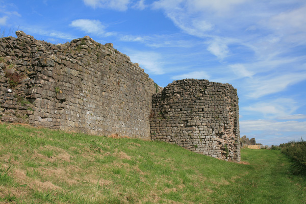
Caerwent was founded by the Romans in AD 75 as Venta Silurum, a market town that served as the local administrative centre for the Silures tribe — a group that had previously distinguished itself as an enduring thorn in Rome’s side (see CA 268). The town is unusual in being largely free of later buildings, bequeathing well-preserved vestiges of the urban fabric, including houses, the forum and a temple. The town walls are especially striking. Still visible for much of their circuit, they stand 5m high in places, making them among the most complete and impressive to survive from Roman Britain.
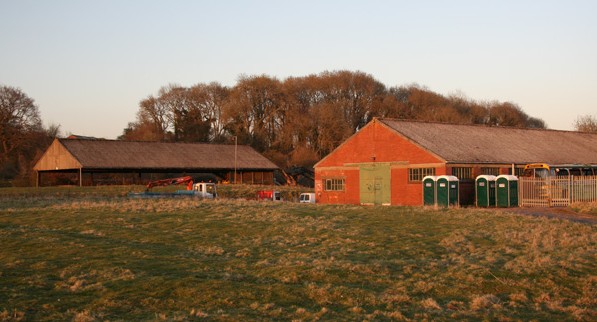
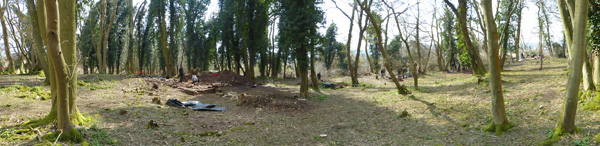
The Whitewall Brake Roman complex lies a short distance north-east of these walls, within the grounds of the Defence Training Estate Caerwent centred on NGR ST47539224. This complex occupies the site of the former Royal Naval Propellant Factory that was constructed by The Admiralty in 1938. Subsequently redesignated as an RAF base storing munitions, the complex is now a training area, primarily used by the Army. Regular visitors to the Roman town at Caerwent that have not heard about the neighbouring military base need not be surprised — until recently the site was top secret, only appearing on OS maps eight years ago.
The natural knoll at Whitewall Brake rises to around 40m OD, dominating the surrounding land on all sides except to the north. The ruins lying on top of this promontory are, in general, well preserved. Such survival can be attributed to limited damage by modern agriculture, the lack of permanent human occupation, and the apparently fleeting antiquarian interest. The site’s location within a secure area has also prevented vandalism and illicit metal detecting.
Although there was uncertainty about how much 19th-century antiquarian activity occurred at the site, the 1913 letter to the Natural Museum of Wales implied that the ruins did not detain the explorers for long. This source also makes frustratingly fleeting reference to the discovery of an intact mosaic, as well as box flue tiles, pottery and coins. The combination of such high-status artefacts with a substantial structure occupying a prominent location overlooking the town led the antiquarians to conclude that they were dealing with an official complex. They felt that the building might be either a mansio — an inn or post house offering rest and a fresh horse to weary messengers carrying official communiques — or the residence of an important local dignitary. Operation Nightingale’s work on the site, however, hints at an entirely different interpretation.
Today, modern building extends to within 10m of the Scheduled Area on gently shelving ground to the north of the earthworks. The natural fall of the ground is steepest to the south, although this is obscured to some extent by a 1938 railway embankment constructed to supply the propellant factory. Sadly, it is no longer possible to determine whether the structure originally continued downslope, as the embankment cut will have destroyed or obscured any remains. Visible structures on the outcrop itself include spreads of tumbled stone, overgrown walls, two lime kilns and quarries. Survey of the earthworks yields the rough outline of a large rectilinear complex of buildings, 100m east-west by 50m north-south.

Modern methods
As Whitewall Brake is a Scheduled Monument (MM152), the first step was to secure permission for Scheduled Monument Clearance — the Crown’s parallel system to Scheduled Monument Consent on MOD property. All Operation Nightingale work at the site was carried out following discussion with Cadw.
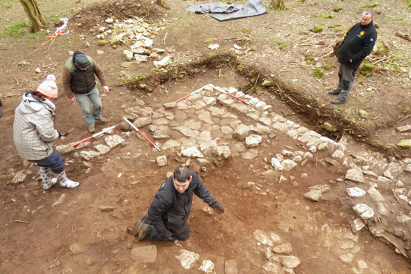
Under the direction of Martin Brown (DIO), Phil Abramson (DIO) and Sgt Diarmaid Walshe, the team set out to test some of the antiquarian assumptions about the site, secure better dating evidence for it, and furnish Cadw with more detailed information about the nature of the deposits. A further key objective materialised after it became apparent that the size and position of the earthworks in the wood did not match their representation on the Schedule Entry or the Ordnance Survey maps. Operation Nightingale’s work offered a perfect opportunity to correct this by undertaking a full, modern survey of the site.
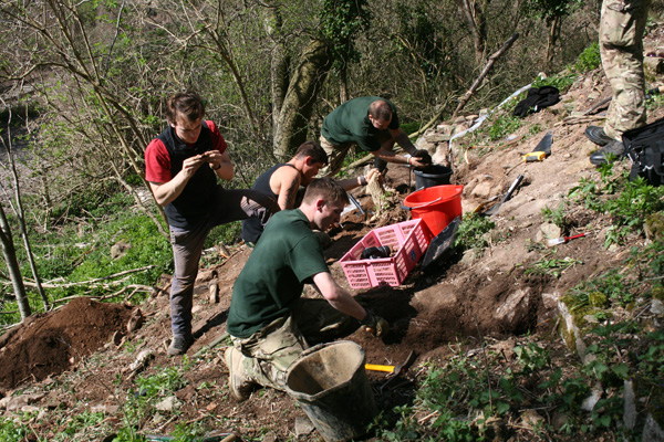
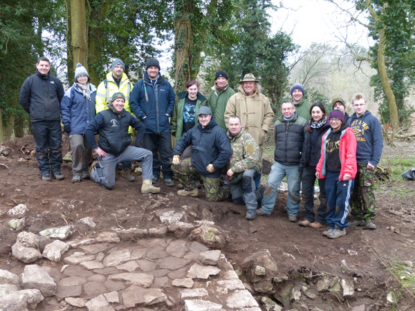
To achieve these aims, the project drew on members of all seven Battalions of The Rifles, who worked alongside students from the University of Leicester under the watchful eye of Prof. Simon James, specialist in Roman archaeology and academic advisor to the project. The team also benefitted from the wisdom, advice and wit dispensed by one Phil Harding, president of the Defence Archaeology Group and well known to readers of this magazine as Current Archaeology‘s Archaeologist of the Year.
Geophysics and radars
After the scrub had been cleared, Peter Masters of Cranfield University helped the injured Riflemen undertake a full geophysical survey of the monument using a gradiometer, as well as more limited investigation with a Ground-penetrating Radar (GPR). The latter generated cross-sections across elements of the structure, and successfully identified the presence of ranges to the north and south of a courtyard. This sequence of features could be convincingly interpreted as wall-floor-wall- open space-wall-floor-wall.
The results of the gradiometer survey were even more exciting, revealing the tantalising outline of a substantial orthogonal-shaped structure at the heart of the Roman complex. While the space within the walls could be used for almost any purpose, when they occur in high-status, architecturally pronounced settings they often serve as lavish dining or reception areas.
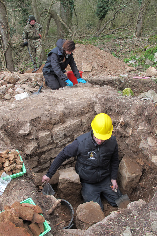
Once the survey data were in, the servicemen and students sunk trenches across the knoll. These targeted areas that appeared to have been damaged by natural tree fall, disturbed by earlier antiquarian diggings or where features that appeared on the geophysics needed clarifying. The features discovered in our trenches provided tantalising new clues about the purpose of the building complex.
Piecing it all together
The first trench was positioned over a void where a fallen tree had torn a chunk of earth from above the line of a Roman wall. It was clear from surface examination that the tree’s trailing roots had exposed and disturbed a substantial masonry deposit. This debris, comprising loose stone and mortar fragments, was carefully examined for any indication of worked architectural features or decorated mortar, but none was found. Some of the stone proved to be common to the local area, but bright white quartz had also been brought in from further afield and would have created an eye-catching glittering façade.
Careful digging exposed the top of a stout, mortared wall. It was assumed that this would fit the published plan of the scheduled building. Instead, its location and course demonstrated fundamental inaccuracies in the published diagram. It did, though, accord with the First Law of Archaeology, in so much as the walling extended beyond the trench and ran under an antiquarian spoil heap.
The Roman masonry still stood up to four courses high. The wall was built of good-quality local stone that had been carefully quarried, dressed and laid. This was carried on a wide, but shallow, mortar foundation which, it quickly became apparent, was simply not up to the job. Rather than digging down to the bedrock, this foundation layer had been laid directly onto the natural soil. Unequal to the pressure, the foundation buckled and fractured. The panicky Roman response was obvious: a large quantity of mortar was poured in to try and make good the failure.
This urgent attempt to shore up the structure appears to have been successful, and the edifice stood for some time before it finally collapsed. In some areas large numbers of flat, squared stones overlay the tumbled masonry. These thin stones had small round holes drilled through them. In one case a rusted, corroded nail remained in place within the hole. These tiles reveal both that the building had a fine stone roof, and that the ruins had remained more or less undisturbed ever since that roof caved in.
Another trench was sited over an area that had been flagged up during our initial survey. Four sheets of partly buried and seemingly deliberately laid corrugated iron were detected. These covered an area of loose earth that had clearly been previously disturbed. Could the metal sheeting have been laid by antiquarians to protect a feature of particular interest? The mosaic mentioned in their correspondence perhaps? Excavation quickly revealed that the answer was ‘no’. The corrugated iron had been lain against fallen Roman masonry to create a ‘basher’ or army field shelter, which had in turn collapsed over time.
This did not mean that there was nothing of interest within the trench, however. Large fragments of Roman wall plaster were found loose in the spoil, disturbed by previous antiquarian and military diggings. Most of this plaster was painted a modest plain white with no traces of more ornate patterning. Two mysterious features emerged at the bottom of the trench. One was a large, 1.6m by 1m flat-bottomed feature cut into the natural bedrock. The other was what appeared to be a substantial rock-cut posthole. Emptying it revealed a small number of pig bones packed into the fill at the bottom. Was this a ritual deposit intended to appease the local gods?

In many ways the most interesting results came from a further, larger trench that targeted the remains of the highest standing structure on the site. This lay in the western corner, where neatly dressed local limestone walling still stood 0.75m high. A squared, hollow depression in this area seemed to indicate that this conspicuous chunk of masonry had also piqued antiquarian interest. Removal of their spoil yielded large quantities of high-quality tesserae — or mosaic squares — some less that 5mm across. Once the former upcast had been cleared, limited excavation of the area within the walling revealed three stone hypocaust pillars. Investigating the heating system will be a key focus of this year’s excavations.
Digging in this trench was expertly undertaken by four soldiers from 3rd Battalion the Rifles who had only just returned from Afghanistan after being injured when their convoy was caught in a roadside explosion. After two weeks immersed in the painstaking world of excavation, one of the soldiers said that he had just had his first proper night’s sleep since the attack. It was a demonstration of the power that the past has to improve the present on a personal level.
Ongoing discussions
As well as supporting the injured riflemen in their ongoing attempts to come to terms with their injuries, the excavations also achieved their archaeological objectives. Most surprising was the discovery that 19th-century activity was on a far greater scale than anyone had previously suspected. So far some 14 antiquarian trenches and associated spoil heaps have been identified, conflicting dramatically with the allusions in the 1913 letter to small-scale digging.
These trenches give some indication of contemporary priorities, with the majority focusing on the course of Roman walls. Such an approach is typical of 19th-century investigation, where identifying and chasing walls to create a plan was the dominant concern. Some of their spoil heaps were imaginatively recycled by the military as sangars — that is firing positions — and bashers for training purposes. The end result is the curious superimposition of a military landscape on a Roman ruin.
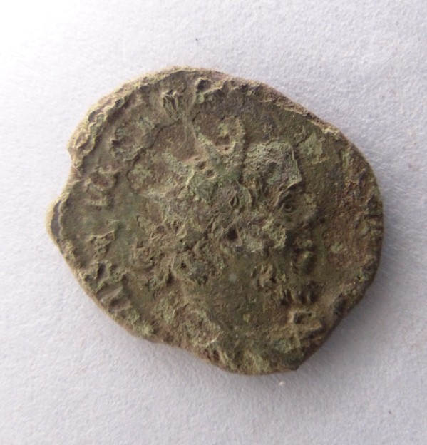
Operation Nightingale’s excavation work at Whitewall Brake has clearly shown that the site represents a large Romano-British building or complex set around a central courtyard. The small assemblage of artefacts gathered so far includes ceramics from a range of Romano-British kilns, as well as imported fine wares from Gaul. Spot-dating this pottery indicates occupation in the 3rd and 4th centuries AD. This conclusion is reinforced by the 24 coins so far uncovered, all of which have been dated to within the period 270-363 AD.
Painted wall plaster, decorated architectural fragments, high-quality stone roofing, masonry, hypocausts and mosaics point to this being a particularly high-status building. All of this fits with its size. Measuring approximately 100m in length, this puts it on a par with major Romano- British buildings such as the sumptuous villa at Woodchester. Yet does the Whitewall Brake complex really have a comparable domestic role?
The small amount of everyday pottery from the site, the presence of mysterious shafts sunk into the bedrock, and in particular its conspicuous location perched on a rocky outcrop could be taken to imply that this was a shrine or temple site. There are certainly parallels with the religious complex at Lydney Park in Gloucestershire.
Such an interpretation will be tested by further work, with careful study of the terrain and a detailed reconstruction of the site being used to establish the nature of its relationship with the nearby Roman town. As well as taking further steps towards solving this archaeological mystery, it is certain that Operation Nightingale’s ongoing fieldwork will continue to help set injured veterans on the road to recovery.


