
 Why transport 82 two-tonne megaliths across more than 250 miles of mountain, river and sea to build a stone circle at Stonehenge? This is one of the greatest mysteries of Britain’s best-known, but least understood, prehistoric monument. Now Tim Darvill thinks he has the answer: the famous bluestones had healing powers, and the builders of Stonehenge were creating a prehistoric Lourdes.
The latest issue of CA tells all.
Despite centuries of study, we seem no nearer to answering such basic questions as what is Stonehenge, who built it and why. The publication in 1965 of Stonehenge Decoded, in which astronomer Dr Gerald S Hawkins argued that Stonehenge was built to observe lunar and solar events, had the surprising effect of silencing speculation for several decades. Hawkins’s arguments – like those of the engineer Alexander Thom whose study of megalithic sites in Britain, published in 1967, supported the idea of widespread astronomical knowledge in Neolithic Britain – seemed to take Stonehenge out of the realms of ordinary archaeological discourse. Instead, Stonehenge became, for a Message in the Stones Why transport 82 two-tonne megaliths across more than 250 miles of mountain, river and sea to build a stone circle at Stonehenge? This is one of the greatest mysteries of Britain’s best-known, but least understood, prehistoric monument. Now Tim Darvill thinks he has the answer: the famous bluestones had healing powers, and the builders of Stonehenge were creating a prehistoric Lourdes. Christopher Catling reports. while, rich territory for mathematicians and astronomers: it even led to the creation of the entirely new (and still thriving) discipline of archaeoastronomy.
Forty years on, a new generation of archaeologists is refusing to be intimidated by complex calculations relating to the solsticial and equinoctial positions of the sun, moon and stars. Amongst them, Professor Tim Darvill of Bournemouth University is bringing fresh perspectives to Stonehenge and its landscape by arguing that Stonehenge, like many prehistoric structures, is a monument with multiple resonances and that the recent obsession with complex astronomical alignments has probably blinded us to simpler explanations about what was going on here in the past.
Back to the source of the stones
From 2002 to 2005, Tim headed a research team that was commissioned by English Heritage to write an archaeological research framework for Stonehenge, set against the background of the Transport Agency’s controversial plans to improve the roads around the monument. Writing this report brought home to Tim two big issues: first, that despite all the research in the Stonehenge area, very little use had been made of landscape theory to bring it all together, and second, that it was the arrival of the bluestones that made Stonehenge special, so that understanding the meaning and purpose of these stones meant looking not only at Stonehenge but also the source area in the Preseli Hills.
Tim set about addressing the first issue by writing Stonehenge: the biography of a landscape, published by Tempus in 2006 (ISBN 0752436414, £25, hdbk), which explores a number of innovative ideas to explain why Stonehenge had a special significance over several millennia. To investigate the second issue, he joined forces with colleague Geoff Wainwright, former English Heritage Chief Archaeologist and now President of the Society of Antiquaries, to start a long-term research programme in north-west Wales, known as SPACES: the Strumble-Preseli Ancient Communities and Environment Study, whose results are published annually in the journal Archaeology in Wales.
Geological parallels
Unlike the stones of the sarsen circle and the five trilithons, which are the dominant feature of today’s Stonehenge, and which were sourced from sites on the Marlborough Downs no more than 40km away, the bluestones had come an impressive distance: from the Preseli Hills of north Pembrokeshire, a distance of some 250km as the crow flies and considerably further by land, river and sea.
Precise identification of west Wales as the origin of the bluestones was made by Herbert Thomas, petrographer to the Royal Geological Survey, in an article on ‘The source of the stones of Stonehenge’, published in the Antiquaries Journal in 1923. Subsequent petrographic and mineralogical analysis has confirmed the accuracy of Thomas’s conclusions.
What Tim discovered, once he and Geoff started fieldwork in the Preseli Hills, is that the Stonehenge bluestones were not placed in a random order: instead they broadly mirror the geology of the Preseli Hills. The 80 bluestones at Stonehenge are set in two concentric rings – the inner oval is made up of spotted dolerite, while the outer circle includes rhyolite and tuff as well as dolerite. It is now clear from the mapping of the quarry sites by the SPACES team that the dolorites derive almost wholly from a rocky outcrop called Carn Menyn, located at the summit of the broad ridge of upland called Carn Meini, while the rhyolites and tuffs come from a range of volcanic dykes, or wall-like outcrops, surrounding this ridge.
Tim sees this correspondence as quite deliberate and highly significant. ‘We can see a geological pattern translated from one context in west Wales to another on Salisbury Plain, and the recreation of the Carn Meini landscape in another location must have some bearing on the interpretation and meaning of the rocks and what they represent to the builders of Stonehenge’, he says.
The glacial drift theory debunked
The placing of the stones also undermines glacial theories about the way that the bluestones reached Stonehenge. Geoff Wainwright jokingly refers to the issue of how the bluestones were transported from Wales as ‘a blue-collar question, not an archaeological one’, but in truth it is no mean achievement to transport some 80 stones – each measuring around 2m in height, between 1m and 1.5 m wide and around 0.8m thick and weighing up to 4 tonnes – over such a great distance and over such difficult terrain.
The suggestion that the stones were transported by glacial action goes back to J W Judd who, in a note in Archaeologia in 1901, drew on the relatively new science of glaciology; what he didn’t know then was that there are no known glacial movements from the last 1 million years that could have moved rocks in an easterly direction. The lack of convincing geological evidence has not stopped various archaeologists from continuing to champion the glacial drift theory 100 years on, but Tim’s finding suggests that the builders of Stonehenge were not collecting stones from Salisbury Plain and erecting them as found, but rather had a deep knowledge of Carn Meini and were consciously erecting a surrogate.
More than just a utilitarian quarry
That leads to the question of why – why was Carn Meini used as a source for the monument at Stonehenge; what was so special about Carn Meini that made it somewhere that people wanted to reconstruct in the form of an avatar, a place that embodied the special properties of the original site?
It is here that the work of the SPACES project comes to the fore. The SPACES fieldwork has been exhaustive in its search for clues to the links between Carn Meini and Stonehenge. Aided by some highly
distinguished volunteer archaeologists, a team of Bournemouth University archaeology staff and students have systematically walked over every inch of Carn Meini, surveying the cairns, megaliths and spring sites, photographing and drawing the mass of quarry debris, the flaking floors, hammer stones and tools that litter the site, previously unnoticed or not recognised for their true significance.
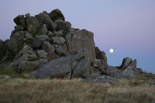
There can be few more dramatic illustrations of the value of this work than to compare the almost blank archaeological map of the area before the recent fieldwork began and the map today, which is crowded with dolmens, portal dolmens, long barrows, circles, standing stones, enclosures, rock art panels and modified springs. Investigations in 2004 revealed a stone wall defining the area of ancient stone extraction at the top of Carn Menyn, and broken monolithsof exactly the same size and proportions as those at Stonehenge are found scattered below the craggy summit – blocks of stone won from the quarry but abandoned because they broke before they could be carried far down the mountainside. At Bedd Arthur, on the next summit west of Carn Menyn, there is even a bluestone oval of such similar size, shape and orientation to the Stonehenge setting, that, according to Tim, ‘it is difficult to believe that they are not the work of the same people’.
Peak sanctuary – the abode of the gods?
The SPACES fieldwork is continuing, along with geophysical survey, trial trenching and environmental sampling, so caution must be exercised before drawing premature conclusions. In his book, however, Tim suggests that everything points to Carn Menyn itself as being a very special part of the Preseli Hills, with the various monuments and landscape features in the wider Carn Meini landscape serving as outworks and signposts to the hilltop. The patterning of monoliths and rock art around the Carn Menyn summit is especially striking, forming an envelope of gateways, places of transition around the summit, whose fingers of shattered dolorite form a dramatic skyline to the peak, resembling the natural stone portals to some kind of peak sanctuary. In lectures Tim teases his audience with possible explanations, asking ‘is this perhaps the abode of the gods, or the birthplace of the ancestors?’.
Then there is the stone itself: called bluestone because of its greenish blue colour when freshly quarried or when wet, dolorite is a very hard rock of volcanic origin with a regular pattern of white feldspar inclusions, like large lumps of sugar. ‘Are these’, Tim asks, ‘a rockbound equivalent of the stars of the night sky, a Milky Way trapped in stone? Do they symbolise some myth, such as the raindrops of the great storm that created the world, or themcrystallised tears of the gods? Might the stone itself be held in high regard for its perceived magical properties?’.
Merlin the magician
Pushed to say what those properties might be, Tim reveals in his book, and elaborated in a lecture to the Society of Antiquaries on 5 October 2006, that there is a clue in a much later source: Geoffrey of Monmouth’s Historia Regum Britanniae. Easily dismissed as a collection of fairy tales (or in Aubrey Burl’s memorably alliterative phrase, as ‘a monkish mixture of Merlin, magic and imagination’), Geoffrey of Monmouth’s 12th-century ‘history of Britain’ might just reflect some faint folk memory in his assertion that Stonehenge was brought from a land far to the west by Merlin the magician, and that the stones were regarded as having healing powers. Stuart Piggott, writing in Antiquity on Geoffrey of Monmouth’s sources, certainly believed that the core of his story – that the stones came from a distant source in the west – embodied genuine folk memories, based on millennia-old oral traditions.
Archaeological support for the healing idea is found in the many springs around Carn Meini to which oral tradition attributes healing properties. These springs have been elaborated by digging back into the source and building walls to create pools; the SPACES team has found a strong spatial link between these elaborated springs and nearby rock art and cairns.
Perhaps then there was an association between the healing properties of the water and the local stone? Was the stone brought to Stonehenge because of its curative properties? Was Stonehenge, in fact, a prehistoric Lourdes?
A place of healing
There is plenty of corroborative evidence for this theory in the burial record written into the Stonehenge landscape. A very high proportion of those laid to rest here suffered from lifethreatening ailments. Of the four examples from the Neolithic period of trepanation, where a hole is drilled or scraped into the skull to relieve pain or brain pressure, two are from near Stonehenge. The Amesbury Archer, whose grave was discovered in May 2002, might have been a pilgrim visiting Stonehenge in the hope of a cure for the horrific injury he had suffered to his left leg, which left him without a kneecap and with a bone infection that would have caused him to suffer constant pain.
Tim’s theory, that Stonehenge was a place for the living, albeit those in need of medical help and perhaps facing imminent death, contradicts an idea developed by Mike Parker Pearson and colleagues involved in the Stonehenge Riverside Project, which sees stone as a metaphor for eternity, while wood stands for transience. In this opposition, Stonehenge was the realm of the ancestral dead, and nearby Durrington Walls was the place where the living held their ceremonies.
But, as Tim’s book so well illustrates, Stonehenge is part of a landscape that has continuously evolved over the last 10,000 years (the first known use of the site dates from 8000 BC and is represented by a line of large Mesolithic postholes ignominiously buried under today’s car park). No single interpretation will ever pin down conclusively what it might,have meant at any one time – just as many churches and cathedrals are not defined exclusively as places of pilgrimage and healing, but as places that support a multiplicity of practices, beliefs and meanings.
Where the bluestones fit in the chronology of Stonehenge
Stonehenge has been remodelled many times in its 5,000-year history. It was a very simple earthwork enclosure in its earliest phase (c 3000 BC), when it consisted of a circular ditch and bank, just like many other ‘henges’ found all over Europe. What turned it from a ‘bog standard’ henge into a unique monument was the introduction, around 2600 BC, of the 80 blocks of bluestone from west Wales, probably set in a double circle; we don’t know precisely because the stones have since been reused and the original plan has been deduced from the scant remains of broken stumps and of the characteristic dumbbell-shaped sockets into which the stones were set.
The next major phase of remodelling saw the introduction of the massive sarsen stone circle of upright stones capped by a lintel that we associate with today’s Stonehenge. This circle surrounds five sarsen trilithons (each made of two uprights and a lintel) set in a horseshoe shape. This phase is dated to between 2440 BC and 2100 BC.
Perhaps as part of this major remodelling, or perhaps sometime up to one hundred years later, the bluestones were moved from the perimeter and rearranged to form a circle between the outer sarsen circle and the inner horseshoe, and an oval inside the horseshoe. The circle is set between the sarsens and the trilithons, and the oval sits at the centre of the monument, with the so-called altar stone at its south-western end. It is
this arrangement that mirrors the geology of the volcanic outcrops on Carn Meini and this oval that resembles the shape and size of the Bedd Arthur bluestone oval. We don’t know yet if the same geological pattern was present in the first bluestone phase, though it might well have done.
The correspondence clearly implies a continuing relationship between Stonehenge and the Preseli Hills, half a millennium after the bluestones were originally erected at Stonehenge. The two monuments might mark the eastern and western extremities of the community of people who built the Bedd Arthur and Stonehenge monuments; but the similarity in architecture and geology suggests a metaphorical link, based on binary oppositions.
Whilst one might speculate endlessly on the possibilities inherent in such ideas, the key point to Tim Darvill’s research is to encourage us to think about Stonehenge – unique as it is in terms of its size, complexity and grandeur – not as an isolated monument, and not one whose links are limited to the immediate Stonehenge environment, but one that is a reproduction of another place, and one whose potency is inextricably linked to a hilltop 250km away in the far west of Wales.


